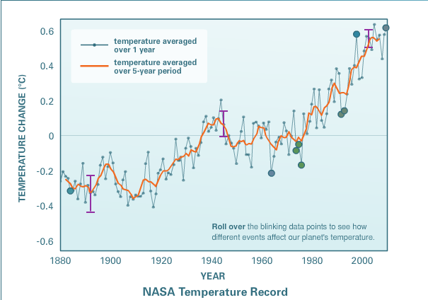
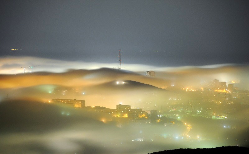
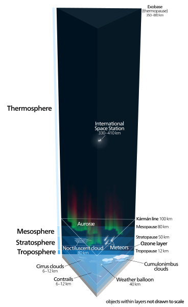
Global warming is defined as "A gradual increase in the overall temperature of the earth's atmosphere generally attributed to the greenhouse effect caused by increased levels of carbon dioxide, CFCs, and other pollutants." To the left is a graph showing the change in the average temperature of the earth since 1880. Click on it to enlarge it. The graph shows a 0.8°C increase in the earth's average temperature since 1880. Overall, the average temperature of the Earth has not increased that much since 1880, not even a full degree Centigrade. However, this does not mean that LOCAL warming is not happening. Just look at the polar ice caps and the rain forests. 
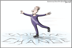
I am going to show you three cartoons on global warming and explain them to you. First is on the left. This cartoon shows a guy skating on top of ice that is cracking. It is a fairly simple cartoon to understand. The guy represents humans, and the thin ice represents the danger that we are in from climate change. If we don't do something to stop it, the ice will melt, there will be lots of floods and other climate problems will happen until the earth is uninhabitable. 
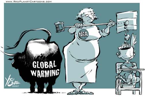
This cartoon is a little harder to understand. It shoes a teacher shoving cow poop into a kid's head, labelling the bull as the cause of global warming. What the cartoon is saying is that cows aren't to blame for climate change, we are. It is emphasizing that to say that cows are the biggest causes of global warming is bull ----. (Sorry, that's what it's saying) 
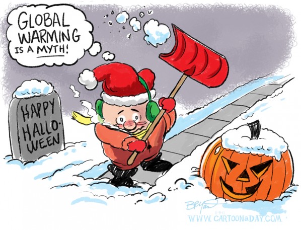
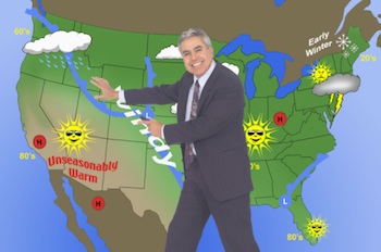
This cartoon is a good example to explain that global warming is not happening; climate change is. Although the average global temperature has stayed within one degree centigrade for over 120 years, that doesn't mean that it hasn't had temperatures drop in certain areas of the world, and rise in others. We need to stop trying to fix nonexistent global warming, and work on fixing climate change. I know, you think its just a title, but what's happening can't be labelled "global warming" because the globe isn't warming.
0 Comments
Today I will be talking about weather fronts and systems, as the vague title might have suggested to some of you ;). Weather fronts are boundaries between two masses of air of different densities. I will discuss the different fronts and pressure systems today. I will also talk about how these are used to forecast the weather. A cold front is the leading edge of a cool mass of air (I don't mean that the air is super popular, I mean 'brrr'). On a weather map, it is show as a blue line with triangle on the line pointing the direction of travel of the front, as you can see on the left. Cold fronts are made of cold air, so they push up the warm air, causing lowered pressure along the cold front. See the diagram below. The lowered pressure means that a cold front will generally be accompanied by unpleasant weather, such as thunder storms or just a cooling of the temperature. A cold front moves faster than a warm front. A cold front usually has a high pressure system, so meteorologists can look at a weather map and find the location of a cold front to determine what the weather will be on a given day. A warm front is the leading edge of a warm mass of air. On a weather map, it is shown as a red line with half-circles pointing in the direction of travel. A warm front is made of warm air, and as it approaches, rainfall steadily increases. It has a lower pressure than cold fronts, so it moves slower than a cold front would. As warm fronts usually have a low pressure system, meteorologists can determine the weather at a given time, same as they would with a cold front. Today I will be talking about weather folklore and proverbs. (again with these cryptic titles, sheesh;) I will discuss ten different weather proverbs and whether (ah ah? :)) or not they are accurate.
I'll start with one of the most well-know proverbs, "Red sky at night, sailors delight; red sky in morning, sailors take warning." This proverb is mostly true as red has the longest wavelength and it can break through thick concentrations of dust and moisture. When those concentrations causes red at night, when the sun is setting, this implies a high pressure system moving from the west which generally means good weather. If, however, the highest concentration is in the morning, when the sun is rising, that implies that there is a high pressure system that has already passed, and a low pressure system is likely to follow. As I have told you before, low pressure systems equal verrry unpleasant weather. You can view a fuller explanation at the Library of Congress' archive here. Next proverb is a bit simpler: "Clear Moon, frost soon." This proverb uses the fact that when the atmosphere is free of clouds, "Clear Moon", there isn't a extra insulating layer of clouds to keep in the heat, which could cause the temperature to lower enough to form frost. Now, this proverb isn't that accurate, because you could have a cloudy winter day that produces frost, and you could also have a clear, warm summer day that doesn't produce frost, even though the sky was clear. So, this proverb is only accurate some of the time in late fall. To be more accurate, it should be re-written as "Clear Moon in late fall, frost is more likely to form". I wonder why they haven't switched to that yet? ;) Third proverb: "A year of snow, a year of plenty". This proverb predicts that if there is constant snow fall during the winter, with no frequent thaws, then the next year's harvest will be plentiful. It is true that the soil will be more fertile if there aren't frequent thaws and freezes, and that less crop seeds will be killed when the ground remains frozen. Constant temperature throughout the winter also prevents fruit trees from blossoming before the killing frost season is over. Fourth proverb: "Crickets are quiet, rain's a comin'" (ok, ok, I made that one up...) Even though you may not have heard this proverb, it is a good example of using nature to predict the weather. Cicada's are not able to vibrate their wings when the humidity is very high, so this could be an indication of rain coming soon. Fifth proverb: "You can find the air temperature to within 1 degree of accuracy 75% of the time by counting the amount of crickets' chirps within a 14 second period and adding 40." That is an actual formula, and is very neat to find out. If you want to see a scientific explanation for this phenomenon, you can go here. The scientific article is here. Sixth myth: "If a groundhog sees its shadow on groundhog day, there will be 6 more weeks of winter." This is a myth, plain and simple. There is no scientific evidence to support the theory that a cloudless day on groundhog day means that there will be six more weeks of winter. In Saskatchewan, though, winter doesn't end until the middle of March anyways, so groundhog day is kind'a pointless. Seventh myth: "When cats sneeze, it's a sign of rain." Okay, this is just ridiculous. Sure, the extra static electricity in the air before a thunder storm COULD cause the fur on a cat to stand up, tickling its nose, causing it to sneeze; but REALLY? That myth is ridiculous. Cats sneeze for the same reason everything else does, something is triggering the sensor on the inside of the nose. God didn't create cats' noses to sneeze to predict the weather and not do anything when their nose is irritated with dust or other particles. This myth is just too ridiculous, so on to the next one. Eighth myth: "Onion skins very thin Mild winter coming in; Onion skins thick and tough Coming winter cold and rough". This myth relies on selective memory, as when it is true, it is well remembered; but when it is false, it isn't important enough to remember that it didn't come true that particular year. That being said, there is some truth to it, as if a year generally has less moisture, the onion's skin will be thinner due to lack of moisture, and the winter will probably be more mild, as there is less moisture for it to hurl at you. So, all in all, this is a myth, but it does have a bit of science to it. Ninth myth: "The squeak of snow will the temperature show." This is partly true, as the colder the temperature of the snow, the louder the crunch. You can see a scientific explanation for that here. Final myth: "When ditches and swamps offend the nose, look for rain and stormy blows.". This is actually a fact; when you can smell that smell, you know it is going to rain. Now, you may think that it has something to do with atmospheric pressure and that cow farm down the road, but it doesn't. (Am I sure that it has absolutely nothing to do with the cows? Um, mostly...) The actual reason is that a bacteria called geosmin lives in the soil in moist conditions and when it dries, it produces spores to survive to the next rainfall. When rain falls on them, they rehydrate and the smell is produced. The reason we smell it during a rain, is because the particles in the soil release the smell as it rains in a location away from you and the wind blows the particles to you. You may be thinking, But how does it stink so much?! Well, its because the human nose is very sensitive to them; it can pick it out if there is just ten parts in a trillion. If you would like a bit more detailed report on them, you can check this out. So, that was my post on weather proverbs and myth. See you next time! Today I will be talking about the differences between radar and satellite weather technologies. Satellite weather technology uses pictures taken from a weather satellite to determine cloud cover and global weather systems. This allows meteorologists to look at the global weather systems to more accurately predict local weather. In essence, weather satellites would be used to look at the global weather to help predict local weather while radar would look at nearby local weather to predict upcoming local weather. (Did I say weather enough in that sentence? These blogs are getting monotonous... :() You can see a picture of North America taken from a weather satellite on the above. Radar weather technology uses radar stations to generate a weather map of the local region. This weather map, complete with the moisture content of the clouds, helps meteorologists determine what the short-term local weather is going to be like. You can see a time lapse of hurricane sandy from a weather satellite below, along with a 7 month time lapse of US weather radar images. Sorry, couldn't find one for Canada.
Today I am talking about weather forecasts. I will show you weather forecasts from three different sources and discuss the differences between them. The first forecast for Regina is from The Weather Network. TWN forecasts that the high for tomorrow will be 0°C, and the low, -17°C. The Weather Channel's forecast has a bit less of a gap, predicting a high of -1°C and a low of -8°C. Finally, the Weather Office of Canada predicts a high of -2°C and a low of -17°C.
There isn't that much of a difference in the three forecasts, except for the Weather Channel's. The Weather Channel, however, is based in the US where they don't have to figure headaches like windchill out. This explains why their low for Monday is a full 9 degrees off from the lows of the other two forecasting services. Other than the windchill, the three forecasts' highs and lows are within a couple of degrees difference. This would be normal as the calculations with the forecasting formulas will differ based on information on hand at the time. Weather Forecasting began with early civilizations monitoring meteorologic and astronomical events to monitor changes in the weather based on the season. Babylonians began trying to predict short term weather around 650 B.C. based on the appearance of clouds and 'halos' (No, they weren't playing video games, they looked at circles of light surrounding an object; in this case, usually the Sun and the Moon). People tried to predict the short term weather using their experiences and folklore up until the end of the Renaissance, when it became evident that these methods were inadequate, and that to accurately predict short term weather, they needed to increase their knowledge of the weather. After that, they continued to refine their instruments and methods for forecasting the weather while observations and technology increased for the atmosphere. (Want a deeper summary? Me neither, but here it is anyways) Now I'll discuss some weather lore. The first, probably everyone has heard: "Red sky at night, sailor's delight, Red sky at morning, sailors take warning." This saying observed that when the sunset was red, there would be dry weather the next day; and that when the sunrise was red there would be bad weather that morning. The second saying is just a myth and actually doesn't have any scientific evidence to prove it. It is: "Cats and dogs eat grass before a rain.". While some observations can of nature can sometimes predict the weather, this is not one of them. Cats and dogs normally eat grass, as they require some vegetation for their health. If you want, you can look on Wikipedia for the scientific explanations for these sayings. (I know Wikipedia isn't allowed as a school resource, but that article is actually very interesting) Today I'll be talking about some weird weather events and the science behind them. I'll look at two unusual weather happenings and try to explain the science that was behind them so that they no longer look weird. First up isn't that strange, but it is unusual, at least in Regina. In June, there were some really weird clouds that showed up after a big thunder storm. These puffy, cotton ball looking clouds are called mammatus clouds. They are usually indicative of an extreme storm, and often extend from the base of cumulonimbus clouds. Aviators are extremely recommended to avoid these clouds, even more than they are recommended to avoid cumulonimbus clouds in general. If you want, you can read the news story here. You might think that this is a little too weird to believe due to the rarity of these clouds appearances, but I assure you, I myself saw them, and if it was faked, there wouldn't have been so many tweets with pictures or the news story on it. The second event isn't really unusual, but it is very freaky. I am talking about hurricanes, specifically Hurricane Sandy. Hurricane Sandy formed on October 22, 2012 and lasted for nine days, ending on the 31st. Classified only as a Class 2 hurricane at its peak, it was still the largest Atlantic hurricane to date. It is ranked as the second-costliest hurricane after hurricane Katrina, causing an estimated 77.43 billion USD in damages. At least 253 people were killed and 15 went missing as the superstorm tore a path through 7 countries. Hurricanes begin their lives as tropical storms. As the storm moves over the ocean, water evaporates and rises until enormous amounts of heated moist are going straight up into the atmosphere. This air feeds the storm, allowing it to grow bigger and faster. What made Hurricane Sandy so destructive was its size. It gained enormous amounts of water when it passed over the warm waters south of Kingston, Jamaica. There are those that would argue that global warming caused Hurricane Sandy to grow in size enough to cause the damages that it did. So, although hurricanes aren't that rare, they are still freaky. If you ever want to read an interesting story on a man-made hurricane destroying the world (fictional of course), check out Skeleton Coast, by Clive Cussler. I found that it helped me understand how hurricanes were formed and how they grow. Anyways, see you for now! My next post will be on Weather Forecasting. (Wait until tomorrow when you Today I'll be talking about events related to the weather. I'll let you in on a little conspiracy theory of mine; hurricane Sandy was caused not by the government, but by the weather! Crazy right? ;) Anyways, I'll be discussing four weather events and their causes. Don't worry, I won't bother with specific instances, I'll just be general so you can actually acquire useful knowledge from this blog for once. ;) First, I'll talk about my arch-nemesis (and occasional ally, depending on the capitalization): Blizzards. Blizzards are defined as "Severe snowstorms with high winds and low visibility." You can see a picture of a blizzard on the left. (I think that's me delivering my paper route yesterday...) As you can see, the conditions that characterize a blizzard are not very pleasant. Snowstorms are categorized as a blizzard when the speed of the wind is equal to or exceeds 56 km/h and the visibility is reduced to 400 meters or less. They are caused by a warm front colliding with a cold front (more on those later). This causes a low-pressure zone, which as all pilots and air cadets know, equals really really bad weather. (let's add a little more really really's...) The snow will be added when the low pressure zone passes over a body of water. A low pressure area creates a lot of high-powered winds. The lower the pressure, the higher the winds. Blizzards should be avoided out of a natural interest in remaining comfortable; but when one is happening on a highway, or any place where one would travel, that place should be avoided at all costs. Blizzards reduce the visibility to near zero, greatly increasing the risks of an accident. They also create slippery roads and gusts of winds that can affect your vehicle. All in all, a blizzard is weather to be avoided (or a snack to be attacked :D) Second part of your force fed diet of weather knowledge; tornadoes. Feeling like you're not in Kansas anymore? Anyways tornadoes are really cool. They can can reach wind speeds of up to 482 km/h and can be 3.2 kilometres across and stay on the ground for more than 100 kilometres. Whoa! I'd hate to be caught up in something like that! Thankfully, tornadoes normally don't get any bigger than 76 metres across and any faster than 177 km/h. That's still pretty insane though. I haven't ever gone faster than 150 km/h my whole life! Tornadoes are defined as "a violently rotating column of air, in contact with the ground, either attached to a cumuliform cloud or underneath a cumuliform cloud, and often (but not always) visible as a funnel cloud". They are formed from a supercell storm when falling rain drags a large amount of air with it. which in turn drags a mesocyclone down to the earth. A mesocyclone is a mass of rotating air within a supercell. Third weather event: Thunderstorms. These are my favourite. The sound of the rain and the thunder outside at night while you're inside listening... Anyways, thunderstorms are defined as "transient storms of lightning and thunder, usually with rain and gusty winds, sometimes with hail or snow, produced by cumulonimbus clouds". These storms are caused by rapid updrafts of warm moist air. If a thunder storm grows big enough it can turn into a supercell and cause a tornado. Cumulonimbus clouds are the types of clouds that characterize thunderstorms. They are big, tall, dark anvil shaped clouds. They can rise to over 20 km where their top is flattened making it look like an anvil due to high winds at that height. To a pilot, these clouds are bad news. Plain and simple. You see one, you go the completely opposite direction. Although these storms are the prettiest, they are also very dangerous. Not only are they dangerous to planes, but also to vehicles and humans. My Dad was driving to Caronport from Moose Jaw and our minivan was hit by a lightening strike. Completely fried the electronics and we had to get a new minivan. People have also been hit by lightening. So, if you are ever caught outside in the middle of one of these, then get to shelter fast! Unless, of course, you purposely chose to be outside in the middle of a thunderstorm, then I would assume that you have taken appropriate measures to protect yourself from lightening strikes. The fourth and final event is the mysterious fog. Fog is actually pretty neat. It's definition isn't nearly as mysterious as it looks; "fog is a collection of liquid water droplets or ice crystals suspended in the air at or near the Earth's surface". However, its definition is exactly what it is. Fog is just semi-frozen water hanging just above the surface. Basically, its a low-lying stratus cloud. It isn't created the same way a cloud would be though. Fog is generally formed from local water supplies, such as a nearby lake or ocean. It is formed when the temperature of the surrounding area and the dew point (temperature at which dew is formed) are less than 2.5°C apart. So, even though it looks the coolest out of the discussed weather events, it is the simplest to explain. Anyways, thus concludes my Weather Related Events blog post. Check back for the next post: Wacky Weather! Okay, So today I'm going to talk about the atmosphere. You have four basic sections of the atmosphere; the troposphere, the stratosphere, the mesosphere, and the thermosphere. Together, they start at the surface and they continue for 350-800 kilometres above the surface of the Earth, with variations due to solar activity. I will now breakdown and thoroughly explain each. The picture on the left is a good example of what the atmosphere looks like. Of course, the separations between the sections of the atmosphere aren't perfectly flat, due to the weather and how it affects those layers. As you can see from the lovely diagram obtained from Wikipedia, the troposphere is the closest layer to the Earth. The stratosphere is the second closest; the mesosphere third; and finally, the thermosphere is last. Now, there is one more layer above the troposphere, it's called the exosphere. I won't be talking about it because it doesn't really behave like the rest of the atmosphere, mainly because it has very few particles (mostly hydrogen and helium) that are so spread out that they could travel hundreds of kilometres before colliding with each other. If you think of the Earth as an orange, and the atmosphere as it's skin, then the exosphere is the thin layer of dust on the surface of the orange. The Troposphere is the first layer of the atmosphere. It begins at the surface of the Earth and extends 9 kilometres at the poles and 17 kilometres at the equator with some variation due to weather. It is where all of the Earth's weather happens, and it is the section of the atmosphere that planes fly through. That makes it my favourite. :) Anyways, the troposphere is heated mainly by transfers of energy on the surface, so the higher it gets, the colder it gets. The troposphere is made up of roughly 80% of the atmosphere. The boundary separating it from the stratosphere is called the tropopause. In the picture on the left, the troposphere is the orange layer, the white layer is the stratosphere, and the blue layer is the mesosphere. The Stratosphere extends from the tropopause to a height of about 51 kilometres. This layer of the atmosphere is where the ozone layer is located. The temperature in the stratosphere actually increases as you get higher! This is due to the absorption of ultra-violet energy by the ozone layer. It is the highest layer of the atmosphere that life can still survive unprotected. Birds will sometimes fly in it, and bacterial life makes it their habitat. The stratosphere is separated from the mesosphere by the stratopause. The Mesosphere starts at the stratopause and continues to a height of 80-85 kilometres. Here, the temperature again decreases as the height increases. The top part of the mesosphere, called the mesopause can be considered the coldest, naturally occurring place on Earth. With temperatures as low as -100° Celsius, it's easy to see why one can't book trips to the mesosphere. ;) Seriously though, out of all the layers of the atmosphere, the least is known about the mesosphere. This is because the mesosphere is between the maximum height for aircraft and the minimum height for orbital spacecraft. Thus, all we know about it is gained from launching sub-orbital "sounding" rockets into it. The Thermosphere is the fourth and final layer of the atmosphere (other than the exosphere). It begins at the mesopause and continues to about a height of 500 kilometres. The temperatures here rise the higher you go, but they are largely dependent on solar activity. The temperature can get as high as 2,500° Celsius, but since the energy lost by thermal radiation would be higher than the energy gained by infrequent collisions with sparsely located particles the actual temperature one would feel would be below 0° Celsius. For a more detailed description on the atmosphere, check out Wikipedia or the video below. Well, this is the first post, so I'll give you a bit of background on the weather. We'll start with the definition of weather. Weather is defined as "the state of the atmosphere with respect to wind, temperature, cloudiness, moisture, pressure, etc." (dictionary.com). Now, I'll give you the definition of Climate. Climate is defined as "the composite or generally prevailing weather conditions of a region, as temperature, air pressure, humidity, precipitation, sunshine, cloudiness, and winds, throughout the year, averaged over a series of years." (dictionary.com). That's a long definition, isn't it? Basically, it can be explained as the general weather that a given region will have most of the time. Now, I'm sure you're wondering who in their right mind would want to have a job related to meteorology (the study of weather), what with all the boring and confusing terms; not to mention that half the time they don't even get it right. Well, let me tell you some of the benefits to being involved in meteorology. (That's right, there are actually benefits to being a meteorologist!) Firstly, the demand. The environmental organizations want a piece of you, places like oceanography departments and atmospheric studies. Then there's the public that wants to know what it's going to be like tomorrow, so you could work for television or be on the good ol' radio. Then there's always important, but not public, weather work; you could work as a forecaster for the pilots that have to fly through the stuff. Finally, there's a standby if you are dedicated enough; you could teach it to other weather fanatics. Crazy right? A never-ending cycle of weather people training other weather people! What is this world coming to? ;) (source) Secondly, the fun. OK, I'm not going to pretend that I enjoy meteorology at all, because I don't, but there are those out there who actually really enjoy working with the weather and trying to figure it out. Look at this guy: Doesn't he look like he's having a blast? Check out this guy, seems like being a weatherman worked out pretty well for him! |
AuthorHey, Luke T here. Found out that I was supposed to be blogging about the weather for my Science a week before it ended. Yeah. My fault though, didn't even start work on the course till I was supposed to be three months through it. Ooopsy. ArchivesCategories |